Historical • Ancient • Louisiana
POVERTY POINT
While Egypt was raising pyramids, someone in Louisiana was doing the same thing. 3,400 years later, we still don’t know who — or why.
Location
West Carroll Parish, Louisiana
Built
~1700 – 1100 BCE
Abandoned
~1100 BCE — reason unknown
Status
UNESCO World Heritage Site

OLDER THAN YOU THINK
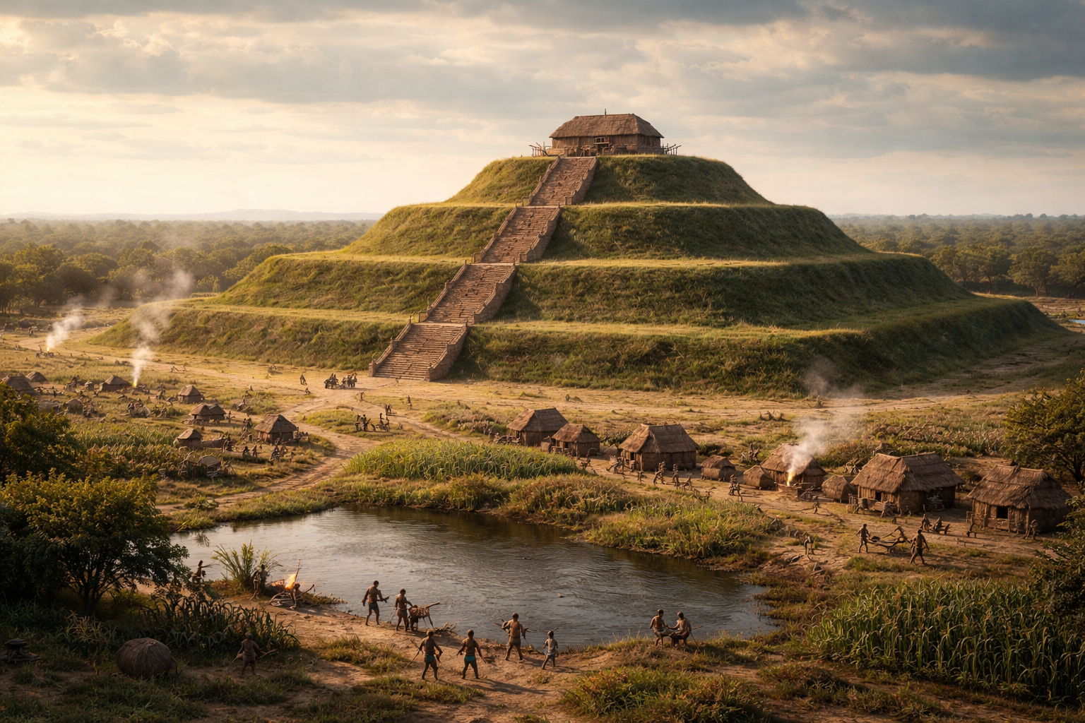
When most people think about ancient pyramids, they think about Egypt. Maybe Mexico. They don’t think about northeastern Louisiana. But they should. Because while the Egyptians were stacking limestone blocks in the desert and Queen Nefertiti was ruling from a throne on the Nile, someone in the swamps of what we now call West Carroll Parish was building their own monument — a 72-foot earthen pyramid, 710 feet long and 660 feet wide, shaped like a bird with outstretched wings.
That’s not a metaphor. Poverty Point was constructed between roughly 1700 and 1100 BCE. The Great Pyramid of Giza was built around 2560 BCE. Stonehenge was erected around 2500 BCE. That puts Poverty Point in the same ancient timeline as the most famous monuments on Earth. And yet most Americans have never heard of it.
This wasn’t some primitive camp. This was one of the first major civilizations in North America — a complex, organized society that predated agriculture itself. These were hunter-gatherers who weren’t supposed to be capable of building anything on this scale. And yet they moved nearly 2 million tons of earth, basket by basket, by hand, to create something that wouldn’t be surpassed in size on this continent for another 2,200 years.
AMERICA’S FIRST CITY
Poverty Point wasn’t just a mound. It was a city — possibly the first true city in what is now the United States. At its peak, as many as 5,000 people lived here on the banks of Bayou Macon, a tributary of the Mississippi River. The complex covers over 400 acres and includes the massive bird-shaped pyramid (known as Mound A), five additional mounds, and six concentric C-shaped ridges that radiate outward from a central plaza like the rings of an amphitheater.
The ridges were used as foundations for homes. People lived on them. They cooked on them — archaeologists have found thousands of small fired clay cooking balls, unique to this culture and now known as Poverty Point Objects. The builders used three distinct types of soil in the construction of the mounds, layered intentionally — different in color and composition — suggesting they understood materials and engineering at a level no one expected from a pre-agricultural society.
And they weren’t isolated. Poverty Point was the center of a trade network that stretched over 800 miles. Stone, copper, and raw materials flowed in from the Ohio River Valley, the Ozark Mountains, and the Tennessee River region. Spear points, jewelry, stone tools, and carved miniature animal beads — owls, dogs, locusts, turkey vultures — have been recovered from the site in staggering quantities. Whatever this place was, it drew people and resources from across the eastern half of the continent.
THE NUMBERS DON’T MAKE SENSE
Here’s what makes Poverty Point genuinely hard to explain. The builders moved an estimated 53 million cubic feet of soil. A cubic foot of earth weighs between 75 and 100 pounds. That’s roughly 3.9 billion pounds of dirt — 1.9 million tons — the weight of 288,000 African elephants or eight of the world’s largest cruise ships. All carried in woven baskets on human backs. No wheels. No horses. No oxen. No metal tools.
And they did it while still living as hunter-gatherers. These people didn’t farm. They hunted game, fished, and gathered wild plants for food. Every other civilization in history that built on this scale — Egypt, Mesopotamia, the Maya — had agriculture to support permanent settlements and feed a labor force. Poverty Point’s builders didn’t. They were supposed to be nomadic, constantly on the move to follow food sources. And yet they stayed in one place long enough to build a monument that took centuries to complete.
Archaeologists and anthropologists are still trying to figure out how this was possible. Some believe Poverty Point was so rich in natural resources — fish from the bayou, game from the hardwood forests, wild plants along the river — that the people didn’t need to farm. Others suggest it was a pilgrimage site, drawing temporary laborers from across the region who came, built, and left. The honest answer is: we don’t know. And that mystery is part of what makes Poverty Point one of the most important — and most overlooked — ancient sites on the planet.
HIDDEN IN PLAIN SIGHT
For centuries, nobody knew what Poverty Point was. The main pyramid — Mound A, the second-largest ancient earthen structure in all of North America — was so enormous and so perfectly integrated into the landscape that archaeologists as late as 1926 thought it was a natural hill. The concentric ridges that stretch over a mile across the site were invisible from the ground. It wasn’t until 1953, when archaeologist James Ford happened to look at Army Corps of Engineers aerial photographs, that anyone realized the ridges were man-made.
Think about that. One of the oldest and most significant civilizations in North America was hiding in the Louisiana countryside for 3,000 years, mistaken for natural terrain. The site sat on a plantation — the Poverty Point Plantation, which gave it its name — and was farmed over for generations before anyone realized they were plowing across the ruins of an ancient city.
Even nearby Watson Brake — another mound complex just 60 miles away — wasn’t discovered until the 1980s and has been dated to 3500 BCE, making it even older than Poverty Point and one of the earliest mound complexes in all of the Americas. Louisiana’s ancient history runs deeper than almost anyone realizes. The first great civilization in North America wasn’t on the coasts or in the mountains. It was right here, in the swamps and bayous of the Mississippi River Valley.
THE DISAPPEARANCE
Around 1100 BCE, after 600 years of continuous habitation and construction, the people of Poverty Point simply left. The building stopped. The population vanished. The mounds were swallowed by vegetation. No one knows why.
There’s no evidence of war. No signs of a plague. No catastrophic flood that can be pinpointed to that era. A later native group added one more mound around 700 CE — nearly 2,000 years after the original builders left — but they occupied only a tiny fraction of the site and stayed briefly. After that, the land sat essentially untouched for almost 3,000 years until European settlers arrived and built a cotton plantation on top of it, completely unaware of what lay beneath their feet.
A civilization that was trading with communities 800 miles away, building monuments on the scale of the Egyptian pyramids, and organizing thousands of people without agriculture — gone. Without a trace. Without an explanation. That’s the kind of mystery that belongs on The Lost Directory.
VISITING
📍 How to Get There
Poverty Point World Heritage Site is located at 6859 Highway 577, Pioneer, Louisiana 71266 — just a few miles off Interstate 20 near the Mississippi-Louisiana border. The park is open daily from 9 AM to 5 PM except Thanksgiving, Christmas, and New Year’s Day.
Admission is $6 per person (ages 7-61), $4 for seniors, and free for children 6 and under. Guided tram tours run four times daily at 10 AM, 11:30 AM, 1 PM, and 3 PM, and cost $10 per person. The on-site museum houses thousands of artifacts including stone tools, carved animal beads, and the distinctive clay cooking balls unique to Poverty Point culture.
You can hike the mounds, walk the ridges, and stand on top of Mound A — the 72-foot pyramid — and look out over the same landscape that 5,000 people once called home. Photography is welcome. The aerial view of the site reveals the geometric precision that’s invisible from the ground — if you have a drone, this is one of the most striking archaeological sites you’ll ever shoot.
You’re standing on 3,400 years of history. The first great civilization in North America wasn’t somewhere exotic — it was in Louisiana. And most of the world still doesn’t know it exists.
PHOTO GALLERY


Replace these placeholders with your own photography or licensed images.
Know more about this location? Have photos to share? Submit your own documentation and help us preserve the memory.